DFHRS - Windhoek 2002
The computation of the DFHRS database the district or the capital Windhoek were performed
in a cooperation project between the RaD project DFHRS at IAF/HSKA and African
Geomatics (Pty), Ltd, Windhoek.
The computation of the DFHRS database for Windhoek was part of the diploma-thesis of Armin
Hoffmann and Stephan Tepper (2002) "Planung, Berechnung und Qualitätsanalyse der DFHBF_DB
Namibia und Windhoek unter Einbindung zusätzlicher GPS-Messungen als Kooperationsprojekt
zwischen African Geomatics und der University of Applied Sciences (FH) Karlsruhe
sowie begleitende C++ Softwareentwicklungen" at the Faculty of Geomatics at HSKA.
The computations were according to the DFHRS approach stage 1, formulas (2a-f).
The fig. below shows the accuracy surface of the Windhoek DFHRS version 1, resulting from the
covariance matrix of the DFHRS parameters p of the adjustment (2a-f), see DFHRS quality control.
The accuracy of the "2-3 cm DFHRS database of Windhoek" was proofed by independent GNSS
measurements (B,L,h) on levelling control points H, which a small standard deviation on
only 9.4 mm for the differences of H = hGNSS - N(DFRHS) and the levelled H.
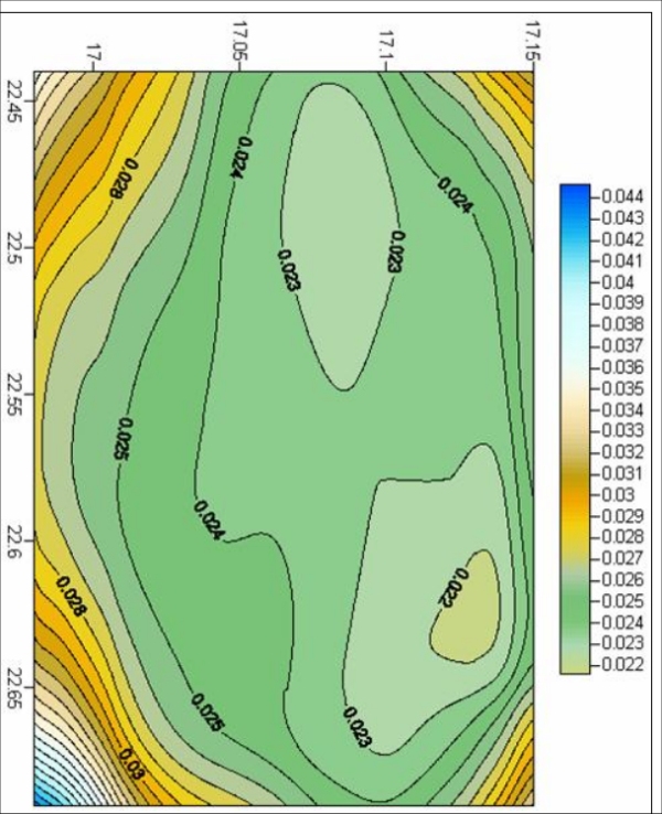
Fig.: Accuracy surface of HRS stored in the DFHRS database of Windhoek.
