DFHRS - Albania 2004
The computation of the DFHRS database was done in a cooperation between the Qendra Gjeofizika
Blloku Vasil Shanto, Tirana, Albania, the Universiteti Politeknik i Tiranes,Fakulteti i
Inxhinjerise se Ndertimit,Departamenti i Gjeodezise, Tirana, the Instituti Gjeografik
Ushtarak i Shqiperise, Tirana, Albania and the RaD project DFHBF at IAF/HSKA in 2004.
The quality of DFRHS database (geoid) is about (5 10) cm. The fig. below shows the isolines
of the HRS N(B,L,h) computed with DFHRS-software version according to the DFHRS approach
stage 1, formulas (2a-f).
The results were presented on the EUREF symposium 2004 at Bratislawa
(Poster-Download)
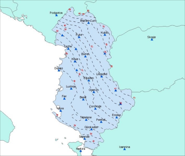
Fig.: Isolines of the Geoid N(B,L) of Albania 2005 computed with the DFHRS software version 4
Geodetic Infrastructures for the Albanian GNSS Positioningservice ALBPOS 2013
Poster presented by Ismail Kabashi, Josef Angst, Michaela Ragossnig-Angst, Reiner Jäger, William Banahene, Simone Kälber and Bilbil Nurce to 17. Internationale Geodätische Woche Obergurgl 2013 "Geodetic Infrastructures for the Albanian GNSS Positioningservice ALBPOS"Paper-Contribution:
Kabashi, I., Angst, J. Ragosssnig-Angst, M., Jäger, R.,. Kälber, S., Banahene, W. and B. Nurce (2013): Geodätische Infrastrukturen für den albanischen GNSS-Positionierungsdienst ALBPOS. (In: Hanke, K.; Weinold, T. Hrsg.). 17. Internationale Geodätische Woche Obergurgl 2013, Wichmann Verlag. ISBN 978-3-87907-526-3.
