DFHRS - Namibia 2002
The computation of the DFHRS databases for Namibia and for the district or the capital
Windhoek were performed in a cooperation project between the RaD project DFHRS at
IAF/HSKA and African Geomatics (Pty), Ltd, Windhoek.
The computation of the DFHRS database for Namibia was part of the diploma-thesis of Armin
Hoffmann and Stephan Tepper (2002) "Planung, Berechnung und Qualitätsanalyse der DFHBF_DB
Namibia und Windhoek unter Einbindung zusätzlicher GPS-Messungen als Kooperationsprojekt
zwischen African Geomatics und der University of Applied Sciences (FH) Karlsruhe sowie
begleitende C++ Softwareentwicklungen" at the Faculty of Geomatics at HSKA. The computations
were according to the DFHRS approach stage 1, formulas (2a-f). Due to the small amount of
only 4 identical points (B,L,h|H) country-wide only 4 patches could be set up (fig.). The
geoid-observations (2b) within the 4 patches were introduced with an accuracy of 0.3 m.
The fig. below shows the accuracy surface of the Namibian DFHRS version 1, resulting from
the covariance matrix of the DFHRS parameters p of the adjustment (2a-f), see DFHRS
quality control. The country-wide mean accuracy of the HRS (geoid), version 1 shows
an only "<_5_dm_DFHRS_DB Namibia". Die improvement of the DFHRS database for Namibia
version 1 can be done - according to the availability of further identical points
(B,L,h|H) and new earth gravity models following the EGM 2006 at any time.
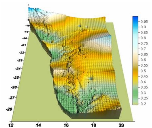
Fig. 1 Accuracy surface of HRS stored in the DFHRS database of Namibia
